An essential, but often neglected, part of engineering a subsea cable system is the route planning and selection. Historically, this has been done using paper charts and manually plotting and evaluating route alternatives.
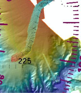
Mallin Consultants pioneered the use of Geographical Information Systems (GIS) to streamline the route engineering process. This allows for much larger datasets to be used in the route analysis, providing for more options to be evaluated in more detail, more quickly than was previously possible.
Multiple data sources, including hull mount and AUV multibeam, sidescan, sub bottom, interpretations and marine charts can be viewed side by side. System data can be updated on the fly and additional data sets added.
Mallin continues to be a leader in using GIS for subsea cable route engineering and documentation of subsea equipment and conditions.